Sierra Morena
Sierra Morena (syāˈrä mōrāˈnä) [
key], mountain range, SW Spain, extending c.375 mi (600 km) eastward along the southern edge of the Meseta (central plateau) from the Portuguese border to the Sierra de Alcaraz. Its highest peak is Bañuelo (c.4,340 ft/1,320 m). Partly forested with oak and chestnut trees, the range is also rich in a great variety of minerals, including copper, lead, and coal. The Sierra Morena is crossed by highways and railroads built to take the minerals out of the region. The Despeñaperros Pass is the main route through the mountains, linking Castile and Andalusia.


Sistema Central
The Sistema Central is a primary feature of the
Meseta Central, the inner Iberian plateau, splitting the meseta into two parts. The Sistema Central runs in a ENE - WSW direction roughly along the southern border of the
Spanish autonomous community of
Castile and León and
Extremaduracontinuing into the
Guarda and
Castelo Branco districts in
Portugal.
Unlike the Sistema Ibérico, the Sistema Central range is a quite homogeneous system. It consists of several ranges that formed 25 million years ago as part of the
Alpine orogeny.
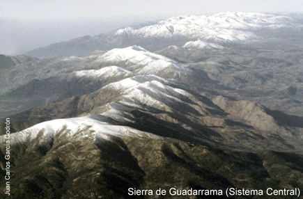
The major mountain ranges are the
Sierra de Guadarrama, which runs approximately along the border of the
Madrid and Castile and León autonomous communities, the
Sierra de Gredos north of the border between Castile and León and
Castile-La Mancha stretching into
Extremadura and containing the range's highest mountain,
Pico Almanzor, at 2,592 m, as well as the
Serra da Estrela, containing the highest point in continental
Portugal,
A Torre, 1.993 m


Montes de León
The Montes de León (
Spanish for "mountains of León", named after the ancient
Kingdom of León) is a
mountain range in north-western
Spain, in the
province of León. This range is located at the confluence of the
Cantabrian Mountains and the
Macizo Galaico. The summits of the range are often covered with
snow in the winter.
The highest peak is
Teleno, at 2,188 metres (7,178 ft). Other important summits are
Cabeza de la Yegua 2,142 metres (7,028 ft),
Peña Trevinca 2,124 metres (6,969 ft) and
Vizcodillo 2,121 metres (6,959 ft).
The
Sierra de la Cabrera is a subrange of the Montes de León.
Macizo Galaico.
Galicia is quite
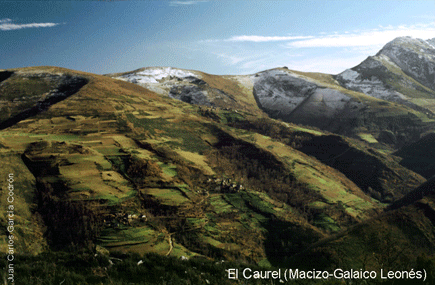
mountainous, a fact which has contributed to isolate the rural areas, hampering communications, most notably in the inland. The main mountain range is the Macizo Galaico (Serra do Eixe, Serra da Lastra, Serra do Courel), also known as Macizo Galaico-Leonés, located in the eastern parts, bordering with
Castile and León. Noteworthy mountain ranges are O Xistral (northern
Lugo), the
Serra dos Ancares (on the border with
León and
Asturias), O Courel (on the border with León), O Eixe (the border between
Ourense and
Zamora), Serra de Queixa (in the center of Ourense province), O Faro (the border between Lugo and Pontevedra), Cova da Serpe (border of Lugo and A Coruña), Montemaior (A Coruña), Montes do Testeiro, Serra do Suído, and Faro de Avión (between Pontevedra and Ourense); and, to the south, A Peneda, O Xurés and O Larouco, all on the border of Ourense and Portugal.
Cordillera Litoral Catalana
The Catalan Mediterranean System, also known as Mediterranean System, Transversal Ibero-Pyrenaean System and Catalanid System
[1]is a wide coastal geographical region in
Catalonia. It is made up of a double system of coastal mountain chains: The
Catalan Coastal Range and the
Catalan Pre-Coastal Range, as well as the
Catalan Coastal Depression and other coastal and pre-coastal plains located among those mountain ranges.